One of the big changes in the upcoming 0.6 release of Semantic Maps will be the from the ground up rewritten semantic datatype for Geographical coordinates. Although the changes themselves do not directly add any value for the user, they enable some pretty neat improvements to existing features, and the creation of many new ones. In this blog post I’ll first go over the changes that are made, in a technical manner, and then sum up the effects they have from an users point of view.
The SMWDataValue extending class for coordinates, which was previously part of Semantic MediaWiki, and only recently moved over to Semantic Maps, has had a big overhaul. This class, now called SMGeoCoordsValue, used to parser coordinates all by itself. Considering Maps also parses coordinates, this is pretty dumb, since the code is redundant, and even worse, does not behave the same way, resulting into incompatible output. I rewrote all the parsing and formatting code in an as modular fashion as possible, and put it in a new class in Maps, which is MapsCoordinateParser. SMGeoCoordsValue now does all formatting and parsing of values via this class 🙂
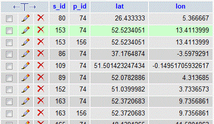
Markus recently added a hook to Semantic MediaWiki that allows for extensions to define their own database tables for storage of semantic values with a specific signature, which will be part of the upcoming SMW 1.5.1. Semantic Maps is using this hook for storing coordinates in a table with lat and lon fields, both floats. This is a huge improvement to simply storing the coordinates in non-directional float notation with the elements separated by a comma, in a string field. The new layout allows for much faster lookups since the values can be index, esp. for things like the soon to be re-implemented distance query, and opens up a lot of new possibilities.
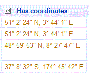
As a user, you will not notice any of these changes, except maybe that things that where broken will be magically fixed when using this new code. Semantic Maps now has settings that allow you to specify the output format of coordinates in queries though, so you can now view them in a different format then non-directional floats, like you where obliged to in the previous releases. You can pick any format supported by Maps, for example directional DMS, as show on the screenshot. Another change is that you will see new functionality based on the new table layout, like, but not limited to, the distance query.
Edit: There actually is one thing you’ll definitely notice as a user when upgrading – you need to update your semantic data via Special:SMWAdmin in order for your wikis coordinates to be stored in the new table. If you don’t do this, queries for coordinates won’t return anything. It’s sort of annoying you need to do this, but there is no way around it.

