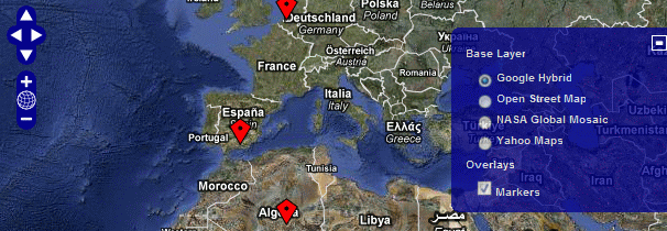
Today and yesterday I made some great progress on the Open Layers facet of Maps and Semantic Maps.
I largely completed the query printer for the openlayer result format, and the pop-up balloons for the markers are finally working. The OL QP was the last big part of the work for the first lease of both Maps and SM. Some issues remaining though, which I’ll try to tackle tomorrow: the pop-up balloons should show the properties of the pages they represent, OL maps created by the OL QP don’t auto zoom and centre yet, Yahoo! Maps popups have some gfx error and some OL code needs to be refactord to solve an issue with default layers and their dependencies.
Map code: {{#ask:[[Category:Locations]]|?Has coordinates|format=openlayer|width=610|height=500|layers=google-hybrid,osm,nasa,yahoo}}
Note that I’ve uploaded my latest code to my on-line dev wiki, so you can now see the result working 🙂
After viewing a video about large scale open source projects and their infrastructure (FOSDEM), and another one about The Myth of the Genius Programmer (GoogleDevelopers), I decided that I should increase the visibility of my project code as soon as possible. I’ve uploaded an archive of my code to my server, and will put it on the MW dev list first thing tomorrow.
